tepetl (Mdz32r)
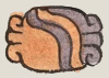
This element for a hill or mountain (tepetl) has been carved from the compound glyph for the place name Ocotepec. It is a classic representation of the tepetl, with its bell-shape colored a two-toned green, the curling rocky outcroppings on the right and left slopes, and the yellow and red horizontal lines at the base. The red line wraps around the yellow line at each end, following the curve of the bottom of the bell shape.
Stephanie Wood
This glyph can provide a phonetic reading of "tepec" (with the implied -c locative), but it can also serve as a silent locative or even refer to an altepetl (town). In many of our compound glyphs for town names, the sound "tepe" or "tepec" does not even come into play, as some of the attestations below will show, and Gordon Whittaker (Deciphering Aztec Hieroglyphs, 2021, 75) refers to it as a semantic complement to other parts of the compound glyph. Given its overlap with altepetl, the water element (atl) that is combined with hill (tepetl) might be implied by the possible opening at the bottom of the hill. The place name Ixicayan, which includes the verb (ixica to leak, combined with the locative suffix -yan), has the leaking water perfectly aligned with the red and yellow horizontal lines at the bottom of the mountain, supporting this interpretation of that being the location of the emergence of liquid. Some have seen in the hill shape a nose or a uterus, both of which have openings, and moisture will emerge from both body parts, too. Thus, the red and yellow lines at the bottom of this sign, tepetl, may indicate access to the interior of the mountain or the place where the precious mountain spring could emerge. Additional support for the red and yellow lines marking the potential emergence of water can be found on the water emerging from the shoulder in the place name, Acolhuacan, as well as the red and yellow surrounding the umbilical cord in the glyph for Xico, near Chalco, published by the University of California, Berkeley. That navel had a connection to a depression at the top of the hill or mountain next to the town, again suggesting an entrance to an internal space.
Stephanie Wood
c. 1541, or by 1553 at the latest
Stephanie Wood

Crystal Boulton-Scott made the scalable vector graphic of the tepetl.
mountains, hills, montañas, cerros, altepetl, stones, piedras, rocks, rocas

tepe(tl), hill or mountain, https://nahuatl.wired-humanities.org/content/tepetl
te(tl), rock or stone, https://nahuatl.wired-humanities.org/content/tetl
el cerro o la montaña
Stephanie Wood
Codex Mendoza, folio 32 recto, https://digital.bodleian.ox.ac.uk/objects/2fea788e-2aa2-4f08-b6d9-648c00..., image 74 of 188.
The Bodleian Libraries, University of Oxford, hold the original manuscript, the MS. Arch. Selden. A. 1. This image is published here under the UK Creative Commons, “Attribution-NonCommercial-ShareAlike 3.0 License” (CC-BY-NC-SA 3.0).