tezacuilli (T2726:8:153r)
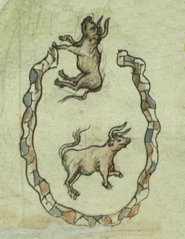
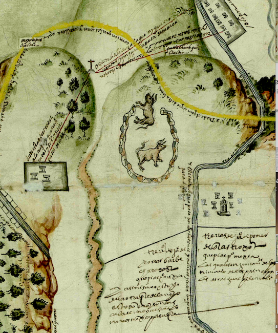
This iconographic image (or possibly simplex glyph) illustrates a corral (tetzacuilli), a name we are giving it based on the term for corral in the Online Nahuatl Dictionary and drawing from Alonso de Molina. The Tetzcocan mapa upon which this element appears lacks a Nahuatl (or Spanish) gloss labeling the corral (see the historical contextualizing image). The corral consists of a color drawing of an enclosure with sides or walls made up of a pattern of semi-rounded elements of alternating, neutral, tan, brown, reddish brown, and green colors (rather than appearing like the more traditional tetl glyph) seemingly intended to indicate that it is constructed of stone. The image is drawn as if the viewer is looking down on the oval enclosure, open at the top (possibly indicating a gateway), and inhabited by two large figures of cattle or oxen. These latter are a semantic element that establishes the corral as a place built to enclose large livestock (ganado mayor). Besides the term tetzacuilli, there are two other possibilities for the Nahuatl word that might have been used at the time by Tetzcoco’s Nahuatl speakers: tepancalli and tepanchinamitl.
Robert Haskett
The so-called Mapa de Patlachiuhqui y Moyotepec, Tetzcoco upon which iconographic image of the corral dates from c. 1592. It was submitted by Indigenous litigants from Tetzcoco, among them Juan de Pomar, who were objecting to an effort by the Spaniard Pedro Mexia de Bocanegra to secure a viceregal grant of a “sitio de estancia y tres caballerías de tierra” (ranch and three caballerías of land) located within the territory of the Nahua city. The grant was not issued thanks to the efforts of the Indigenous litigants. Teresa Rojas Rabiela, who has studied the mapa, emphasizes that many pictorial elements in it indicate both the persistence of traditional ways and the influence of the Spanish, the latter of which would include a stone corral designed for the enclosure of introduced European livestock. For more information, see Teresa Rojas Rabiela, “El paisaje del agua y la tierra de la Acolhuatllalli a través del mapa de Patlachiuhqui y Moyotepec, Texcoco, 1592/Water and Soil in the Landscape of Acolhuatlalli, based on the Map of Patlachiuhqui and Moyotepec, Texcoco, 1592,” Relaciones: Estudios de Historia y Sociedad, 40:160 (Invierno 2019), 7-34, https://www.revistarelaciones.com/index.php/relaciones/article/view/665/....
Robert Haskett
1592
Robert Haskett
corral, pen, enclosure, stone wall, encerramiento, muro de piedra, cerca

tetzacuil(li), a corral or pen, https://nahuatl.wired-humanities.org/content/tetzacuilli
tepancal(li), enclosure, pen, corral, https://nahuatl.wired-humanities.org/content/tepancalli
tepanchinami(tl), something surrounded by a wall or fence, https://nahuatl.wired-humanities.org/content/tepan-chinamitl
el corral
Robert Haskett
Single-page codex, Archivo General de la Nación, México, Ramo de Tierras Vol. 2726, Exp. 8, Fol. 153r.
The Archivo General de la Nación (AGN), México, holds the original manuscript. This image is published here under a Creative Commons license, asking that you cite the AGN and this Visual Lexicon of Aztec Hieroglyphs.


