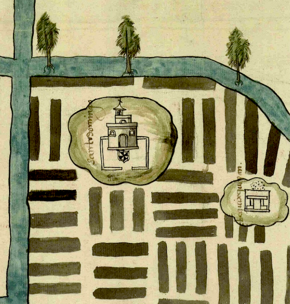
chinampas (T2681:6:2r)
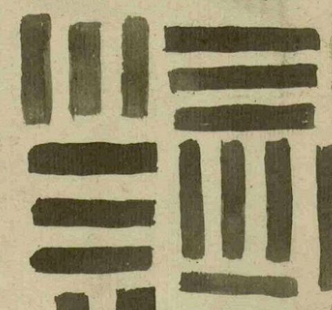
This example of iconography shows an area of chinamitl) agriculture--also known as chinam(pan) and, in the Hispanized plural noun, chinampas. These dark, narrow rectangles are found on am Indigenous-style map (1579) from the region of Cuitlahuacan, Chalco, in the Valley of Mexico. Thus the representation of these artificial, raised fields, constructed in shallow parts of lakes in the valley, is likely to betray a certain amount of Spanish artistic influence (see older examples, below).
Robert Haskett
The way the groups of furrows in chinampas alternate perpendicularly is reminiscent of a glyph that Elizabeth Hill Boone highlights in Painted Words: Nahua Catholicism, Politics, and Memory in the Atzaqualco Pictorial Catechism, Boone, Burkhart, and Tavárez eds., Washington DC: Dumbarton Oaks, 2017, 48 and 72. [Thanks to James Maffie for bringing these comparisons to the fore (personal communication 13 March 2025).] See another similar example in our Mapas Project.
According to Nahua petitioners from Cuitlahuacan, led by the pueblo’s gobernador don Estéban de Caravajal, a man named Bartolomé Arias was attempting to gain a grant of a house lot and two agricultural parcels ("huerta" in Spanish) from the viceregal authorities that would compromise the Nahuas' land tenure and their ability to grow traditional crops such as maize and chiles there. Arias’ effort eventually failed. The type of property in dispute is labeled camellones (agricultural ridges) by whomever provided the Spanish glosses on the map, but “translated” in related documents by Indigenous witnesses and a Spanish surveyor as either chinamitl or chinampas (for instance, the surveyor reported that they are “camellones que los yndios llaman chinampas”).
Areas of human habitation on the same map seem to be represented, in part, by buildings situated on black-outlined, ovoid elements with green shading that are not anything like the chinampan elements. Instead, it is possible that they are islands. In fact, one of the Spanish records associated with the map contains the statement that one of them, Michcalco, is situation on something “like a kind of island” (folio 4 recto). Whether this is a natural feature, a more substantial kind of chinamitl, or a combination of these things is not entirely clear, but two of them lacking representations of buildings are glossed as tierras rather than as camellones (see the historical contextualizing image).
Robert Haskett and Stephanie Wood

chinamitl
chinamitl
Robert Haskett
1579
Robert Haskett
chinampas, camellones
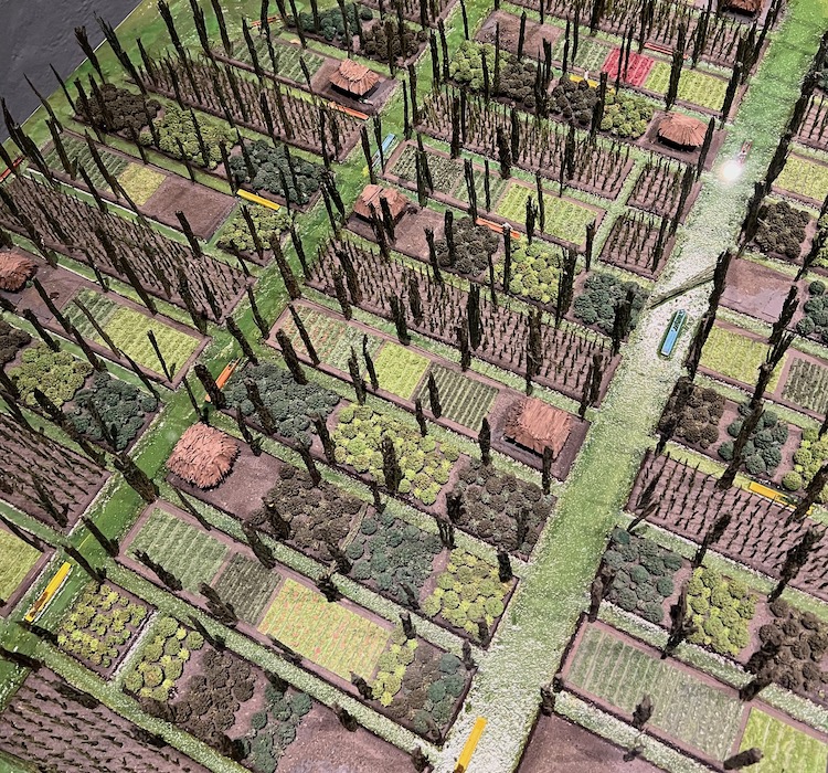
Photograph of a model of chinampa agriculture by Stephanie Wood, 15 February 2023.
chinami(tl), a chinampa or agricultural strip, https://nahuatl.wired-humanities.org/content/chinamitl
chinam(pan), a long narrow extension of farm land built by human hands and stretching into the freshwater lakes around Mexico City, entered Spanish as chinampa, https://nahuatl.wired-humanities.org/content/chinampan
chinampa
Robert Haskett
Single-page codex, Archivo General de la Nación, México, Ramo de Tierras Vol. 2681, Exp. 6, Fol. 2r.
The Archivo General de la Nación (AGN), México, holds the original manuscript. This image is published here under a Creative Commons license, asking that you cite the AGN and this Visual Lexicon of Aztec Hieroglyphs.