Ometepec (CmpRG)
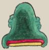
This iconographic element depicts the hill or mountain (tepetl) called Ometepec (“At Two Mountains”). It appears on the map accompanying the 1580 Relación Geográfica de Cempoala (Hidalgo). It consists of one element, a rendition of a green-shaded, twin-peaked hill or mountain with a light pink mouth-like element at its base. The glyph originally appeared upside-down in relation to the gloss identifying it (see historical contextualizing image and gloss). There is no visual representation of the locative -c. Parts of the black outline and green body of the are missing along its edges due to some splicing of the paper that has taken place at some point in time.
Robert Haskett
The iconograph for Ometepec is superimposed on a larger natural feature shaded in lighter green, part of which is glossed as (Hu)itznavac (Huitznahuac; the first two letters are lost in what may be a latter repair that joined or rejoined together two of the sheets of the paper used for the map; see historical contextualizing image). Unfortunately, the alphabetic text of the Relación Geográfica de Cempoala does not include an answer to item 18, which requests information about such things as “alguna sierra o cordillera” (some mountain or mountain range) in the region, but it does state in the response to item 16 that there are some “cerros no muy altos” (hills that are not very high) in the area without, however, naming Ometepec or Huitznahuac. Both of these elevations also are featured as being near one another on a 1590 pictorial created during an investigation of a request for a land grant in the area (see other entries for both in the Visual Lexicon of Aztec Glyphs). For a study of the RG, see Mundy, Barbara E., “Mapping Babel: A Sixteenth-Century Indigenous Map from Mexico,” The Appendix, 1:4 (October 2013), https://theappendix.net/issues/2013/10/mapping-babel-a-sixteenth-century..., Mundy (1996), and Ballesteros García (2005), 65, figure 34.
Robert Haskett

ometepec
Ometepec
Robert Haskett
1580
Robert Haskett
hill, mountain, cerro, nombres de lugares

ome, two, but can also mean dual, https://nahuatl.wired-humanities.org/content/ome
tepe(tl), hill, mountain, precipice, https://nahuatl.wired-humanities.org/content/tepetl
cerro doble
Robert Haskett
Relación de Cempoala - University of Texas Libraries Collections. 1580-11-01. https://collections.lib.utexas.edu/catalog/utblac:f87917e2-e3c9-4eb2-a83....
Materials that are in the public domain (such as most of the maps in the PCL Map Collection), are not copyrighted and no permission is needed to copy them. You may download them and use them as you wish. The image appears here courtesy of the University of Texas Libraries, The University of Texas at Austin.