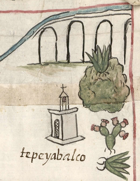
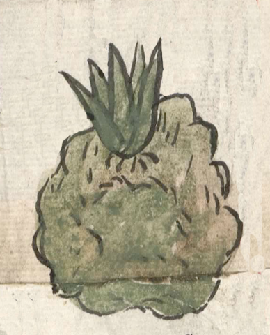
Tepeyahualco (CmpRG)
This is a simplex glyph for the place called Tepeyahualco ("Round Hill"). It appears on the 1580 Relación Geográfica de Cempoala (originally Cempohuallan, and now Zempoala, in the modern state of Hidalgo). The glyph pictures a hill or mountain [tepetl that is round [yahual(li rather than having the traditional bell-shape. Whether or not this “round hill” glyph betrays Spanish cultural influence is currently open to question. The maguey-like plant sprouting near the top of the glyph does not contribute to its meaning, but may be a semantic indicator of the vegetation growing in the area. The hill is outlined in black and shaded in green and brown tones. The locative -co is not represented visually, but the local landscape shown in the compound may serve as a semantic locative. Ithe hill's surface has lines that suggest contour, and its outline is bumpy, perhaps for the same reason; it provides a three-dimensionality. The fact that this is an inhabited place rather than simply a feature in the landscape is signaled by the presence of a church building to its left. This is a common technique used by the creators of this map (see the historical context image).
Robert Haskett
The simplex glyph for Tepeyahualco, the church, and the alphabetic gloss (see below) appear near one of the corners of the map and just below a drawing of four arches with a stream of blue water flowing over them (see the historical contextualizing image). This latter element is a semantic element signaling the presence of aqueduct mentioned in the Spanish-language text of the Relación. On folio 1r it is described as “unos arcos de cal y canto” (“some arches of mortar and stone”). This may be what Peter Gerhard calls “the great aqueduct which carried water from Tecaxete to Otumba” (pgs. 68-69). While both distance and direction is hard to determine exactly on the map (as Barbara E. Mundy has observed, the map “has no fixed orientation”), it does seem as if Tepeyahualco was near to this significant water source. The artist who created the map also shows a fruit and flower laden nopal cactus and a second maguey plant to the right of the town’s Catholic church, once again possible semantic elements indicating the kinds of plants that grew in the area (suggesting, too, that despite the presence of the aqueduct the place was in a fairly arid territory). Peter Gerhard tells us that the Cempoala region is “a rolling, maguey-covered country of volcanic cones rising slightly above the plain…” that in the later sixteenth-century began to sprout haciendas devoted to pulque production (pgs. 67-68). For a study of the RG (which, however, does not mention these particular figures), see Mundy, Barbara E., “Mapping Babel: A Sixteenth-Century Indigenous Map from Mexico,” The Appendix, 1:4 (October 2013), https://theappendix.net/issues/2013/10/mapping-babel-a-sixteenth-century..., the same author’s The Mapping of New Spain (1996), and Ballesteros García (2005), 50-51, figure 2. For information about the Cempoala region, see Gerhard, Historical Geography of New Spain (1972).
Robert Haskett

tepeyaualco
Tepeyahualco
Robert Haskett
1580
Robert Haskett
nombres de lugares, hills, mountains, cerros, rounded, redondo
tepe(tl), hill, mountain, precipice, https://nahuatl.wired-humanities.org/content/tepetl
yahual(li), something round, etc., https://nahuatl.wired-humanities.org/content/yahualli
El Ccerro Redondo
Robert Haskett
Relación de Cempoala - University of Texas Libraries Collections. 1580-11-01. https://collections.lib.utexas.edu/catalog/utblac:f87917e2-e3c9-4eb2-a83...
Materials that are in the public domain (such as most of the maps in the PCL Map Collection) are not copyrighted, and no permission is needed to copy them. You may download them and use them as you wish. The image appears here courtesy of the University of Texas Libraries, The University of Texas at Austin. If you do publish anything from this database, please cite the Visual Lexicon of Aztec Hieroglyphs.