Tzapotla (CmpRG)
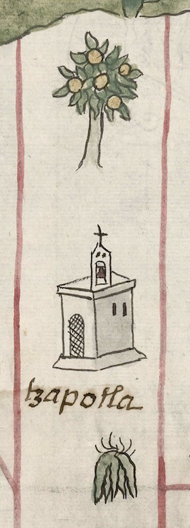
This iconographic element or possible simplex glyph showing a tzapotl tree shows the place known as Tzapotla. It appears on the map accompanying the 1580 Relación Geográfica de Cempoala (Hidalgo). It consists solely of an image of a zapote tree, or tzapocuahuitl (referred to as such by Fray Bernardino de Sahagún in Book 11 of the Florentine Codex), bearing its fruit, (tzapotl), the latter word seeming to provide the root for the place name. The locative -tla, place of abundance of, or, if the final "n" has been inadvertently dropped, -tlan, by, among, in, etc., is not visualized. The tree, outlined in black, is painted in a naturalistic style that may betray some Spanish artistic influence. It has a tan, slightly bowed trunk but does not display its roots, an artistic convention found in other, more “Indigenous” renderings of such things (see below). It has bushy green foliage and bears five round yellowish fruits.
Robert Haskett
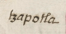
This iconographic element for Tzapotlan stands within a narrow, red-bordered rectangle. These boxes, found all over the map, are elements that Barbara E. Mundy regards as marking off divisions between territories held by Cempoala’s subject communities. Below it is a drawing of a European-style church with a small bell tower topped by a cross. The pairing of a glyphic element with a church is commonly found on the map. The churches seem to function as semantic elements emphasizing that “this is an inhabited place” rather than only some kind of natural feature in the landscape. Indeed, the Spanish text of the Relación emphasizes that all of Cempoala’s dependent communities have churches. The name of Tzapotlan is also signaled by an alphabetic gloss which does include the locative that is not rendered in the iconographic zapote tree element (see the historical contextualizing image and gloss). For more information about this Relación, see Mundy, Barbara E., “Mapping Babel: A Sixteenth-Century Indigenous Map from Mexico,” The Appendix, 1:4 (October 2013), and the same author's The Mapping of New Spain: Indigenous Cartography and the Maps of the Relaciones Geográficas (Chicago and London: The University of Chicago Press, 1996), particularly pg. 129 and her discussion of the function of the red lines seen on the map.
Robert Haskett
tzapotla
Tzapotla (or Tzapotlan, if the -n has inadvertently dropped away)
Robert Haskett
1580
Robert Haskett
place names, zapotes, trees, árboles, nombres de lugares, topónimos, toponyms
tzapo(tl), a type of fruit, https://nahuatl.wired-humanities.org/content/tzapotl
tazpocuahuitl, a fruit-bearing tree; a zapote tree, https://nahuatl.wired-humanities.org/content/tzapocuahuitl-0
-tla, place of abundance of a thing, https://nahuatl.wired-humanities.org/content/tla-1
-tlan, by; among; in; to; between; in the company of; below; near, https://nahuatl.wired-humanities.org/content/tlan
El Lugar de Muchos Zapotes
Relación de Cempoala - University of Texas Libraries Collections. 1580-11-01. https://collections.lib.utexas.edu/catalog/utblac:f87917e2-e3c9-4eb2-a83...
Materials that are in the public domain (such as most of the maps in the PCL Map Collection) are not copyrighted, and no permission is needed to copy them. You may download them and use them as you wish. The image appears here courtesy of the University of Texas Libraries, The University of Texas at Austin. If you do publish anything from this database, please cite the Visual Lexicon of Aztec Hieroglyphs.


