Acatlan (T2680:19:9r)
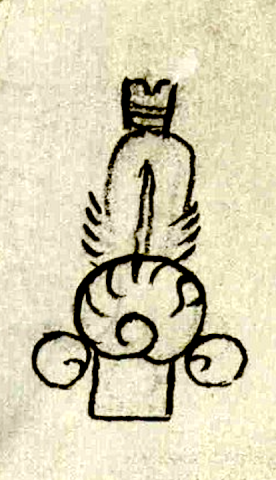
This simplex glyph names the pueblo of Acatlan (“Near the Reeds”) located in the Tulancingo, Hidalgo, region. This place name therefore is made up of acatl), reed, and the locative (not visualized) -tlan. Rather than a depiction of a reed-like plant, this glyph resembles the fletched end of a dart or arrow. The use of an arrow to represent acatl is not unusual see below), since reed canes were commonly used as shafts for these kinds of projectiles. The glyph here has a notched, banded, box-shaped element at its top (presumably showing where an arrow would have been inserted along the bow string), with a feather below this. As the shaft continues there is a large circular element (with black markings inside of it) that represents a down feather or perhaps a ball of down, with two smaller circular elements flanking it (also down feathers). Again, this combination of feathers is seen in other depictions of arrow fletching (see below). The glyph ends with a bit of the shaft outlined in black. A Nahua reading the glyph would have to know that the reference was to a reed and to a community rather than to a word with the root “dart” or “arrow” (most likely mitl). But here an alphabetic gloss comes to the literate colonial-era reader’s aid (see gloss).
Robert Haskett
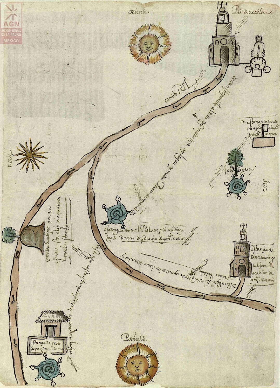
Acatlan’s glyph appears in the upper right-hand corner of the map (the direction “east” in its orientation). It is linked to a drawing of a church, a semantic indicator that this is a “pueblo,” a statement seconded by the alphabetic gloss appearing just to the right of the building’s bell tower (see the gloss and the historical contextualizing image). This structure undoubtedly represents the Augustinian monastery church of San Miguel Arcángel The church is outlined in black and filled with gray and brown shading. It has a large arched doorway connected with a curving road glossed as a Camino Real edged in black lines and filled with tan pigment that also sports a series of human footprints. The church has a round window flanked by two smaller arched openings above the door and is topped by a bell tower surmounted by an orb and cross. The side walls of the church are shown in perspective. All of this betrays a fair amount of Spanish artistic influence in its composition. The map itself was included among a relatively small number of Spanish-language folios concerning a request submitted to the viceregal authorities by the Spaniard Melchor de Carejas for a grant of a sitio de estancia para ganado menor (site for a small livestock—in this case cabras [goats]). In 1564 the request was investigated and witness testimony was taken, all of which characterized the proposed goat ranch as posing no threat to the wellbeing of the people of Acatlan or their agricultural lands. The pueblo’s gobernador at the time, don Domingo de Alvarado, was informed of these proceedings, but neither he nor any other Indigenous town council members seem to have resisted the grant.
Robert Haskett
Pu.o de acatlan
Pueblo de Acatlan
Robert Haskett
1564
Robert Haskett
reeds, cañas, feathers, plumas, nombres de lugares

Acatlan, place of reeds, https://nahuatl.wired-humanities.org/content/acatlan
aca(tl), reed, cane, component of darts and arrows, https://nahuatl.wired-humanities.org/content/acatl
-tlan, a locative, by among, in, near, https://nahuatl.wired-humanities.org/content/tlan
el lugar de las cañas
Robert Haskett
Single-page codex, Archivo General de la Nación, México, Ramo de Tierras Vol. 2680, Exp. 19, Fol. 9r, Acatlan, Tulancingo.
The Archivo General de la Nación (AGN), México, holds the original manuscript. This image is published here under a Creative Commons license, asking that you cite the AGN and this Visual Lexicon of Aztec Hieroglyphs.


