chantli (CmpRG)
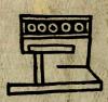
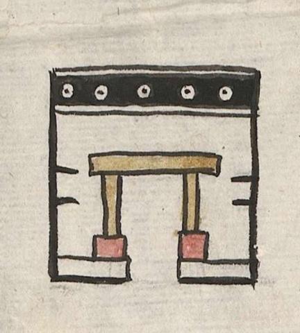
This is a simplex glyph or an iconographic example of a ruler's home, and thus probably also a royal palace (tec(pan)). It appears with a frontal perspective on the map included with the 1580 Relación Geográfica de Cempoala (Hidalgo). It hass a row of five concentric circles just below the building’s flat roof. These circles are white within a black background. The inner circle is filled in with black. The lintel and sides of the doorway are tan, with column-like bases in red. The rest of the building is not shaded, though there are two short horizontal black lines, one above the other, on either side of the tecpan. The whole of the building is outlined in black.
Robert Haskett
The circles just below the roof are a common element on regal structures, suggesting power and prestige, and underlining the building’s status as something much more important than a simple calli (house). The palace depicted on the Relación is glossed as being “the home of Itzcohuatzin, ruler of Mexico” (see gloss). Because of these royal associations, we feel justified in suggesting that it is also tecpan or tecpancalli. Elsewhere, such structures can also identified with terms such as huei tecpancalli, and less commonly as tecpanchan. While the image of the palace is enough to establish that building’ status, Barbara Mundy has observed that the gloss “shows how a picture…triggered historical associations on the part of the map’s viewer,” but that the precise nature of that association was “set down in alphabetic writing (see citation, below).” The Spanish-language text of the Relación adds a little more information on the subject, noting in section 14 (fol. 1v) that “when Itzcohuatzin [ruled 1427-1440] was lord in Mexico the pueblos of Zempoala, Tlaquilpan, and Tecpilpan passed into the dominion of Mexico.” Whether or not a building (or remnants of it) associated with the Mexica ruler was still standing in Cempoala around 1580, or the artist who created the iconographic image for the map was merely conveying a bit of information deemed to be historically significant in the life of region, is not clear. For more information about the Relación, see Mundy, Barbara E., “Mapping Babel: A Sixteenth-Century Indigenous Map from Mexico,” The Appendix, 1:4 (October 2013), and the same author’s book, The Mapping of New Spain: Indigenous Cartography and the Maps of the Relaciones Geográficas (Chicago and London: The University of Chicago Press, 1996), 175 (quote, above).
Robert Haskett
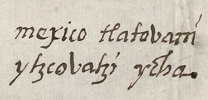
mexico tlatouani ytzcouatzi ychan
Mexico Tlahtoani Itzcoatzin ichan
Robert Haskett
1580
Robert Haskett
palaces, houses, homes, casas, palacios, hogares, tlatoani, tlahtoani, tlahtoqueh, tlatoque, nombres de lugares
chan(tli), home, https://nahuatl.wired-humanities.org/content/chantli
tecpan, noble house, royal palace, government building, https://nahuatl.wired-humanities.org/content/tecpan
tecpancal(li), royal homes, or buildings pertaining to great lords (see Molina); palace or community house, https://nahuatl.wired-humanities.org/content/tecpancalli
huei tecpancal(li), royal houses or palaces of great lords, https://nahuatl.wired-humanities.org/content/huei-tecpancalli
tecpanchan, government palace, https://nahuatl.wired-humanities.org/content/tecpanchan
el hogar
Robert Haskett
Relación de Cempoala - University of Texas Libraries Collections. 1580-11-01. https://collections.lib.utexas.edu/catalog/utblac:f87917e2-e3c9-4eb2-a83...
Materials that are in the public domain (such as most of the maps in the PCL Map Collection) are not copyrighted, and no permission is needed to copy them. You may download them and use them as you wish. The image appears here courtesy of the University of Texas Libraries, The University of Texas at Austin. If you do publish anything from this database, please cite the Visual Lexicon of Aztec Hieroglyphs.