Hueitepec (CmpRG)
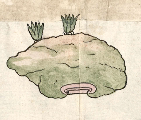
This is a simplex glyph naming the town called Hueitepec (also spelled Hueytepec). This hieroglyphs is featured in the 1580 Relación Geográfica de Cempoala (originally Cempohuallan, and now Zempoala, Hidalgo). Following the accompanying alphabetic gloss (see below), the name consists of huei, “big, large,” tepetl), “hill, mountain,” and the locative -c, “in, on, at.” This locative is not visualized, but the hill serves as a semantic indictor of place. This hill is represented in a frontal view, and it appears as a very large, somewhat amorphous shape. The breadth of the hill is a visual recognition of the term "huei." It is topped by two maguey plants that indicate the flora found in the area. The hill is outlined in black, is colored with greens and browns, and has a series of wavy black lines inside of it suggesting its contours. Its base shows a fairly typical element of three outlined horizontal bars, the upper one curling around the other two, colored in a faded red.
Robert Haskett
Hueitepec was a sujeto (dependent town) of one of the four Cempohuallan cabeceras (head towns), Tzacuala. Its status as an inhabited place is indicated semantically by a three-quarters drawing of a church, an element that usually serves as a semantic indicator of “inhabited place” on this map. For more information about the RG map, see Biblioteca Digital Mexicana, A.C., http://bdmx.mx/documento/mapas-relaciones-geograficas-cempoala-epazoyuca... Mundy, Barbara E., “Mapping Babel: A Sixteenth-Century Indigenous Map from Mexico,” The Appendix, 1:4 (October 2013), Mundy (1996), and Ballesteros García (2005), 64.
Robert Haskett
ueitepec
Hueitepec
Robert Haskett
1580
Robert Haskett
big, grande, hills, mountains, cerros, montañas, magueyes, nombres de lugares

huei, big, large, https://nahuatl.wired-humanities.org/content/huei
tepe(tl), hill, mountain, https://nahuatl.wired-humanities.org/content/tepetl
-c, in, at, on, https://nahuatl.wired-humanities.org/content/c
el cerro grande
Robert Haskett
Relación de Cempoala - University of Texas Libraries Collections. 1580-11-01. https://collections.lib.utexas.edu/catalog/utblac:f87917e2-e3c9-4eb2-a83...
Materials that are in the public domain (such as most of the maps in the PCL Map Collection) are not copyrighted, and no permission is needed to copy them. You may download them and use them as you wish. The image appears here courtesy of the University of Texas Libraries, The University of Texas at Austin. If you do publish anything from this database, please cite the Visual Lexicon of Aztec Hieroglyphs.


