Xaltepetlapan (MH625r)
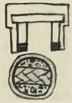
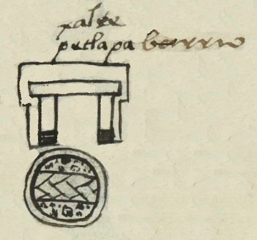
This black-line drawing of the compound glyph for the place name Xaltepetlapan (perhaps "On the Sandy Mountains") is a bird's eye view of a circle with two halves. The top half contains sand (xalli), which appears to be mixed with stone (tetl), another part of the place name. Xaltetl is pumice, and so the sand and stone could provide phonetic indicators for this term. Or this could just be a visual for sand. The bottom half contains a woven mat (petlatl). This seems to be a phonetic indicator for tepetla (mountains or mountainous region). The locative suffix (-pan, on) is not shown visually. But the church next to the place glyph (or part of it) provides a semantic locative. The building above the circle provides a visual, but silent, semantic locative (covering the suffix, -pan).
Stephanie Wood
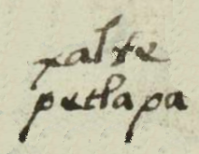
xalte
petlapa
Xaltepetlapan
Stephanie Wood
1560
Jeff Haskett-Wood
stones, piedras, arena, petates, nombres de lugares, barrios, casas, edificios, topónimos, Xaltepetlapan

xal(li), sand, https://nahuatl.wired-humanities.org/content/xalli
tepetla, a mountainous region, https://nahuatl.wired-humanities.org/content/tepetla
te(tl), rocks, stones, https://nahuatl.wired-humanities.org/content/tetl-0
petla(tl), woven mat, https://nahuatl.wired-humanities.org/content/petlatl
-pan (locative suffix), on, https://nahuatl.wired-humanities.org/content/pan
En las Montañas Arenosas
Stephanie Wood
Matrícula de Huexotzinco, folio 625r, World Digital Library, https://www.loc.gov/resource/gdcwdl.wdl_15282/?sp=332&st=image.
This manuscript is hosted by the Library of Congress and the World Digital Library; used here with the Creative Commons, “Attribution-NonCommercial-ShareAlike 3.0 License” (CC-BY-NC-SAq 3.0).


