Xochitepec (CmpRG)
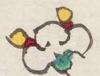
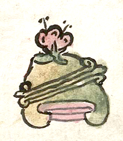
This compound glyph names the place known as Xochitepec (Zempoala, Hidalgo). It appears on the map accompanying the 1580 Relación Geográfica de Cempoala (Hidalgo). The black-outlined glyph consists of a green and tan hill or mountain (tepetl) with a pink flower (xochitl) sprouting from its summit. Two or more stamens or pistils with anthers are visible above the tripartite petals. The The hill has the typical element (for this manuscript) of black-outlined pink stripes, curled at each end, at its base. The band running diagonally across the hill is an elongated element meaning rock or stone (tetl outlined in black. It is both a phonetic complement emphasizing the -te- syllable in the name, and also works as a semantic indicator showing that the hill is rocky. The locative -c is not visualized, but perhaps the landscape provides a semantic locative.
Robert Haskett
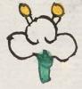
This compound glyph for Xochitepec appears on the edge of the map just above the head painted on the top of the central tepetl glyph for Cenpoualla (Cenpohuallan, Zempoala). It appears in a rectangle bordered with red lines and sits next to a drawing of a church with a bell tower topped with a cross. This structure, which in keeping with the style of communication found on the map, is a kind of semantic element that exablished Xochitepec as an inhabited place. The box, which is an element that Barbara E. Mundy believes is marking off divisions between territories held Cempoala’s subject communities, also contains semantic elements that must indicate what kind of plants growing in the vicinity, in this case a nopal cactus, a maguey plant, and some kind of tree (see the historical contextualizing image). Peter Gerhard tells us that the Cempoala region is “a rolling, maguey-covered country of volcanic cones rising slightly above the plain…” that in the later sixteenth-century began to sprout haciendas devoted to pulque production (pgs. 67-68). As with any place named in some way with a tepetl glyph, a deeper reading suggests that Xochitepec may well have been located near (or on, originally) a hill given the same name. For more information about this Relación, see Mundy, Barbara E., “Mapping Babel: A Sixteenth-Century Indigenous Map from Mexico,” The Appendix, 1:4 (October 2013), and the same author's The Mapping of New Spain: Indigenous Cartography and the Maps of the Relaciones Geográficas (Chicago and London: The University of Chicago Press, 1996), particularly pg. 129 and her discussion of the function of the red lines seen on the map. For information about the Cempoala region, see Gerhard, Historical Geography of New Spain (1972).
In some flowers, such as this one, the anthers are rather pronounced. The anthers are the flower parts that produce and provide the pollen, which has the reproductive capacity that has been compared in Western cultures to semen.
Robert Haskett and Stephanie Wood
xochitpec
Xochitepec
Robert Haskett
1580
Robert Haskett
place name, flower, flor, hill, mountain, cerro, montaña, nombres de lugares, fonetismo
xochi(tl), flower, https://nahuatl.wired-humanities.org/content/xochitl
Xochitepe(c), name of a town, https://nahuatl.wired-humanities.org/content/xochitepec
tepe(tl), hill, mountain, precipice, https://nahuatl.wired-humanities.org/content/tepetl
En el Cerro de la Flor
Robert Haskett
Relación de Cempoala - University of Texas Libraries Collections. 1580-11-01. https://collections.lib.utexas.edu/catalog/utblac:f87917e2-e3c9-4eb2-a83...
Materials that are in the public domain (such as most of the maps in the PCL Map Collection) are not copyrighted, and no permission is needed to copy them. You may download them and use them as you wish. The image appears here courtesy of the University of Texas Libraries, The University of Texas at Austin. If you do publish anything from this database, please cite the Visual Lexicon of Aztec Hieroglyphs.