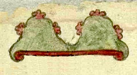
Ometepec (T2781:11:511r)
This late-sixteenth-century place glyph is for the hill or mountain (tepetl) called Ometepec (literally, “in, at, or on two [dual/twin] mountain”). It consists of one element, a rendition of two hills joined together. The image of the glyph originally appeared upside-down in relation to the gloss identifying it (see historical contextualizing image and gloss). The twinned hills are colored in green with a red band with curled ends running along their shared base. Each of these elevations has three light brown three-lobed rocky outcroppings. They look something like truncated and rounded fleur-de-lis. Each peak has one on the top and one on each slope. There is no visualization of the -c locative, but it might be implicit in the hills ("at or on the hills").
Robert Haskett
The place glyph Ometepec appears among a cluster of other images of tepetl on the lower left side of the manuscript (see the historical contextualizing image). The pictorial was created sometime around 1590 and was included among the folios of an investigation into a request made by Luis de Sandoval for a grant of a sitio de estancia de ganado menor (ranch for small livestock) and six caballerías of land, property that appears to have been located in the general vicinity of the twin hills or mountains and within the limits of the municipality of Cempohuallan (Zempoala, Hidalgo, today). The requested sites are also in the vicinity of the pueblos of Tlaquilpan and San Antonio Octoyuca [sic], and very near to the tepetl of Huitznahuac. Ometepec and Huitznahuac are depicted as being right next to each other on the map that is included with the Relación Geográfica de Cempoala. See a digital copy of the RG text and map that is available through the Benson Latin American Collection, University of Texas at Austin. The Tierras 2781 pictorial itself is discussed by Ana Pulido Rull in Mapping Indigenous Land: Native Land Grants in Colonial New Spain (Norman: University of Oklahoma Press, 2020). An image of the manuscript is found as Plate 4 in that book.
Robert Haskett
ometepeq[ue]
Ometepec
Robert Haskett
1590
Robert Haskett
hills, mountains, cerros, dos, nombres de lugares

ome, two, but can also mean dual, https://nahuatl.wired-humanities.org/content/ome
tepe(tl), hill, mountain, precipice, https://nahuatl.wired-humanities.org/content/tepetl
En el Cerro Coble
Robert Haskett
Single-page pictographic manuscript, Archivo General de la Nación, México, Ramo de Tierras Vol. 2781, Exp. 11, Fol. 115r.
The Archivo General de la Nación (AGN), México, holds the original manuscript. This image is published here under a Creative Commons license, asking that you cite the AGN and this Visual Lexicon of Aztec Hieroglyphs.


