nauhcampa (FCbk7f10r)
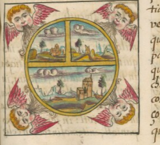
This iconographic example, featuring the cardinal directions (nauhcampa), is included in this digital collection for the purpose of making potential comparisons with related hieroglyphs. The term selected for this example comes from the companion text found in the Digital Florentine Codex. This example shows a very Europeanized visual of the four “winds”--nevertheless called ehecatl (Nahuatl for wind) in the text. Inside a square, in the four corners, cherub heads blow wind in toward the center. They have golden hair, rosy cheeks, and red and pink wings. Farther inside the square is a circle with a yellow border and internal divisions of yellow, too. This is what is called a T-O map in European terms (Orbis Terrarum), as the team at the Digital Florentine Codex point out. One division, a half, appears on the bottom of the circle, and the upper half is divided farther into two, creating two quarters. Inside these three sections of the circle are landscapes and cloudy skies. The bottom half and the upper left quadrant have churches, trees, and mountains. The upper right quadrant has only a tree and some peaks. In all sections, the clouds are gray and white, with a three-dimensionality. The two churches are also drawn in a way that shows three-dimensionality. The artistic styles definitely express a strong European influence.
Stephanie Wood
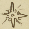
The text gives the Nahua names of the four directions and the four “winds” (ehecatl): Mazahuacan or Mazahuahcan (west); Mictlampan (north); Tlalocan (east); Cihuatlampan ehecatl (west wind); Huitztlampan ehecatl (south wind); Mictlampan ehecatl (north wind); and Tlalocayotl (east wind). In the advanced search in this digital collection, one can ask to see quatrefoils or quincunxes. There are many shapes that suggest an association with such a cosmos, but especially glyphs for tonalli (day, sun) and olin (movement). Ball courts had a four-part division, and each one had a coloring that seems to have had a connection to a cardinal direction. Also worth noting is how hieroglyphic writing and landscape painting will sometimes merge in maps of the Relaciones Geográficas. See some examples below.
The four winds also appear in the corners of a different arrangement in the Códice Durán, published in a vignette by Marc Thouvenot: https://vignettes.sup-infor.com/imagen/DU_03_318r_a.
Stephanie Wood
nauhcampa
nauhcampa
Stephanie Wood
1577
Jeff Haskett-Wood
mapas, maps, planos, nahui, cuatro rumbos, puntos cardinales, viento
nauhcampa, in or toward the four directions, https://nahuatl.wired-humanities.org/content/nauhcampa
los cuatro puntos (o vientos) cardinales
Stephanie Wood
Available at Digital Florentine Codex/Códice Florentino Digital, edited by Kim N. Richter and Alicia Maria Houtrouw, "Book 7: The Sun, Moon and Stars", fol. 10r, Getty Research Institute, 2023. https://florentinecodex.getty.edu/en/book/7/folio/10r/images/0 Accessed 14 July 2025.
Images of the digitized Florentine Codex are made available under the following Creative Commons license: CC BY-NC-ND (Attribution-NonCommercial-NoDerivs 4.0 International). For print-publication quality photos, please contact the Biblioteca Medicea Laurenziana ([email protected]). The Library of Congress has also published this manuscript, using the images of the World Digital Library copy. “The Library of Congress is unaware of any copyright or other restrictions in the World Digital Library Collection. Absent any such restrictions, these materials are free to use and reuse.”


