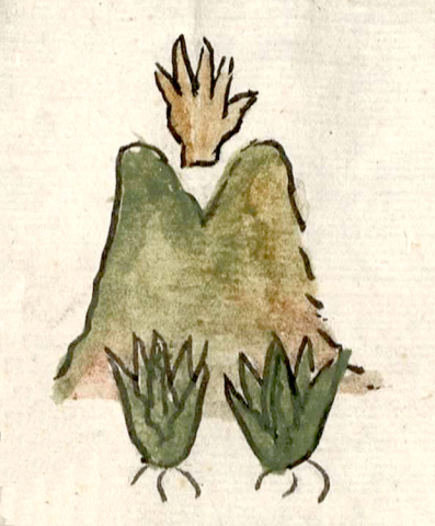
Tepemaxalco (CmpRG)
This is a compound place glyph for the community of Tepemaxalco ("On Forked Mountain"). The first part of the name is established by the figure of the hill or mountain (tepetl), outlined in black and shaded in green, brown, and tan (it lacks the typical, black-outlined and often colored stripes, curled at each end, at its base). The second part of the place name, maxal-, is indicated by two elements in the glyph. The hand (maitl), outlined in black and shaded in tan, at the division of the hill into twin peaks is a phonetic complement that reinforces the fact that the adjective “forked” (maxaltic) begins with ma-. The locative -co is not visualized, but the local landscape shown in the compound may serve as a semantic locative. The two maguey-like plants shown at the base of the hill do not perform any phonetic function, but they serve a semantic function regarding what is cultivated in the area. The placement of this compound glyph next to an image of a European-style church (most likely the church of San Juan), reinforced by the alphabetic gloss of the town’s name, also plays a semantic role in emphasizing that this is an inhabited place rather than only a natural feature of the landscape (see the historical contextualizing image and the gloss).
Robert Haskett and Stephanie Wood.
The semantic role of church structures is found elsewhere on the map, and this has been noted, as well, by Barbara E. Mundy (see below). The Relación text itself states that all of Cempoala’s dependencies have churches. On the map, Tepemaxalco is located a distance to the left of the main glyph of the cabecera of Cenpoualla (Cempohuallan, Zempoala). Vegetation shown next to the glyph and church is in keeping with the landscape of the region, which Peter Gerhard describes as “a rolling, maguey-covered country of volcanic cones rising slightly above the plain…” (67). The glyph is also situated below and to the left of a series of arches drawn on a corner of the map that according to the Spanish text of the Relación were part of a stone and mortar aqueduct bringing water into the region. This may be what Peter Gerhard describes as “the great aqueduct which carried water from Tecaxete to Otumba” (pgs. 68-69). As Barbara Mundy has noted elsewhere, the “Cempoala map…has no fixed orientation and the presumed viewer is a mobile one.... To see the map, you must move around the work reorienting yourself to its features” (see her article cited, below). Indeed, it has no indications of cardinal directions similar to those found on other mapas dating from the later sixteenth century and found in archival collections, such as in the Ramo de Tierras of the Archivo General de la Nación, México: a sun and/or an alphabetic gloss for west or east (poniente o oriente), a star and/or alphabetic gloss for north (norte), and so forth. For a study of the RG, see Mundy, Barbara E., “Mapping Babel: A Sixteenth-Century Indigenous Map from Mexico,” The Appendix, 1:4 (October 2013), https://theappendix.net/issues/2013/10/mapping-babel-a-sixteenth-century..., the same author's Mapping of New Spain(1996), and Ballesteros García (2005), 50, figure 1. For examples of pictorial maps with indications of the cardinal directions see AGN Tierras Vol. 2519, Exp. 8, Fol. 57r (Cuapantzingo y Xochitepec, Tlaxcala, 1575) and AGN Tierras Vol. 41, Exp. 2, Fol. 27r (Cuahtinchan, Texcoco, 1583). For information about the Cempoala region, see Gerhard, Historical Geography of New Spain (1972).
Robert Haskett
tepemaxalco
Tepemaxalco
Robert Haskett and Stephanie Wood
1580
Robert Haskett
nombres de lugares, hills, mountains, cerros, something forked, bífurcado, hands, manos

tepe(tl), hill, mountain, precipice, https://nahuatl.wired-humanities.org/content/tepetl
ma(itl), hand, arm, https://nahuatl.wired-humanities.org/content/maitl
maxal(tic), bifurcated, divided, something that forks or has a Y shape, https://nahuatl.wired-humanities.org/content/maxaltic
En el Cerro Bifurcado
Stephanie Wood
Relación de Cempoala - University of Texas Libraries Collections. 1580-11-01. https://collections.lib.utexas.edu/catalog/utblac:f87917e2-e3c9-4eb2-a83...
Materials that are in the public domain (such as most of the maps in the PCL Map Collection) are not copyrighted, and no permission is needed to copy them. You may download them and use them as you wish. The image appears here courtesy of the University of Texas Libraries, The University of Texas at Austin. If you do publish anything from this database, please cite the Visual Lexicon of Aztec Hieroglyphs.


