
Yohualtianquizco (RGTyM17)
This black-line drawing of the compound Nahuatl hieroglyph for the place name Yohualtianquizco (perhaps "At the Nighttime Market") shows a hill or mountain (tepetl), which is a silent, but visual, locative, and does not play a role in the toponym other than serving perhaps as the -co locative suffix. Sitting atop the hill or mountain is a black circle with three white vertical rows inside the circle. These strips contain double rows of what are probably stars (citlalin), indicating that part of the toponym derives from the word for night (yohualli). Also a part of the name is -tianquiz- (from tianquiztli, market).
Stephanie Wood
Many hieroglyphs for markets are round (see below), so the circle may account for the -tianquiz- portion of the toponym, along with the sky. Skies can also be round, and sometimes they have round stars in them. These stars can be starry eyes or just round white dots.
Stephanie Wood
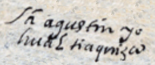
Sā agustin yo
hualtiaquizco
San Agustín Yohualtianquizco
Stephanie Wood
1582
Jeff Haskett-Wood
hills, mountains, cerros, montañas, noche, estrellas, mercados, tianguis, pueblos, estancias, topónimos, nombres de lugares

yohual(li), night or nighttime, https://nahuatl.wired-humanities.org/content/yohualli
tianquiz(tli), marketplace, https://nahuatl.wired-humanities.org/content/tianquiztli
-co (locative suffix), in or at, https://nahuatl.wired-humanities.org/content/co
"Night Marketplace," Barbara E. Mundy, The Mapping of New Spain (1996, 147).
The source of these hieroglyphs is a manuscript and map known collectively as the “Relación de Tistla y Muchitlan,” also known as the “Descripción de la Alcaldia Mayor de las Minas de Zumpango.” Apparently, these towns (today spelled Tixtla and Mochitlan) are in the modern-day state of Guerrero, but they fell under the religious jurisdiction of the Diocese of Tlaxcala. Thanks go to Octavio Márquez for his contribution of the glyph, gloss, and contextualizing images.
The original manuscript is hosted on line as part of the Benson Latin American Collection, The General Libraries, University of Texas at Austin, https://collections.lib.utexas.edu/catalog/utblac:fbc92b3e-bb28-4258-975.... It is open-access.
