Tlacotzintlanapan (RGTyM17)
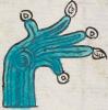
This is a drawing--partially painted--of the compound glyph for the place name Tlacotzintlanapan (perhaps "Sticks Below the River"). The sticks (tlacotl) that are part of the name consist of eight vertical lines close together. A spray of blue water, perhaps a river or a canal (apantli), shoots out to the left with three little streams. Below these two elements is a hill or mountain glyph (tepetl), but it does not have a phonetic role in the name. It may just be a visual, but silent, locative.
Stephanie Wood
A dropped "z" is presumed, but perhaps tlacotin- (and not tlacotzin-) is the real intention.
Stephanie Wood

San pedro tlacon
tintlanapan-
San Pedro Tlacotzintlanapan
Stephanie Wood
1582
Jeff Haskett-Wood
sticks, palos, agua, water, hills, mountains, cerros, montañas, nombres de lugares, topónimos, pueblos, estancias

tlaco(tl), sticks, center, https://nahuatl.wired-humanities.org/content/tlacotl
tlaco, half, https://nahuatl.wired-humanities.org/content/tlaco
tzintlan, beneath, below, at the foot of, https://nahuatl.wired
apan(tli), canal, ditch, or river, https://nahuatl.wired-humanities.org/content/apantli
"River Beneath the Sticks," Barbara E. Mundy, The Mapping of New Spain (1996, 147).
Los Palos Debajo del Río
Stephanie Wood
The source of these hieroglyphs is a manuscript and map known collectively as the “Relación de Tistla y Muchitlan,” also known as the “Descripción de la Alcaldia Mayor de las Minas de Zumpango.” Apparently, these towns (today spelled Tixtla and Mochitlan) are in the modern-day state of Guerrero, but they fell under the religious jurisdiction of the Diocese of Tlaxcala. Thanks go to Octavio Márquez for his contribution of the glyph, gloss, and contextualizing images.
The original manuscript is hosted on line as part of the Benson Latin American Collection, The General Libraries, University of Texas at Austin, https://collections.lib.utexas.edu/catalog/utblac:fbc92b3e-bb28-4258-975.... It is open-access.