Huitznahuac (CmpRG)
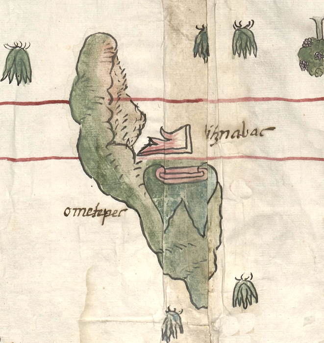
This compound glyph for the toponyum Huitznahuac ("Near the Thorns") includes a hill or mountain (tepetl). It appears on the map accompanying the 1580 Relación Geográfica de Cempoala (originally Cempohuallan) from Hidalgo. It consists of two elements, a naturalistic painting of a rocky peak shaded in brown (rather than a traditional tepetl glyph) showing obvious European influence, and a thorn glyph (huitztli) outlined in black and shaded from almost red to pink above and slightly to the right of the mountain. The thorn’s barbs are facing to the right. On the map, Huitznahuac is shown right next to the tepetl named Ometepec (see the historical contextualizing image). There is no specific visualization of the -nahuac element (next to), but perhaps the landscape provides a semantic locative.
Robert Haskett
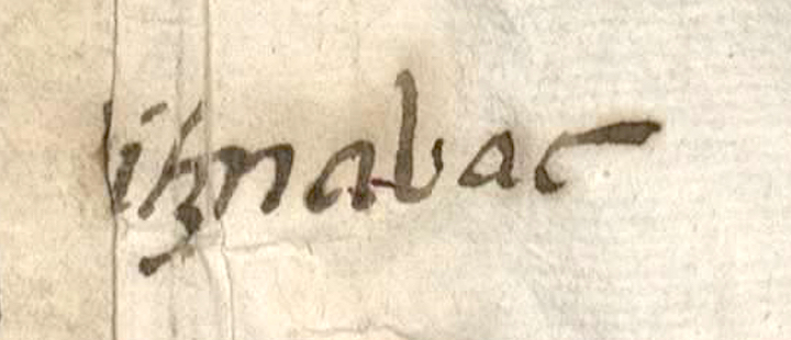
The compound glyph for Huitznahuac of 1580 exists in two worlds as far as its representation is concerned: it relies on a European depiction of a hill, or tepetl, and an Indigenous glyph for thorn/huitztli, to convey its meaning. The colorant used on the thorn do recall earlier glyphs for thorns that were typically red and white--the red, possibly a reference to blood, given that thorns were used for bloodletting from the ears and the tongue. It is transitional in this way, as is its placement immediately next to a more traditional rendition of a second peak, Ometepec (see historical contextualizing image). The gloss for Huitznahuac is damaged, in that it is missing its first two letter (hu-), the result of a repair made at some point to the paper on which the map was painted. The alphabetic text of the Relación Geográfica de Cempoala (modern Zempoala) does not include an answer to item 18, which requests information about such things as “alguna sierra o cordillera” (some mountain or mountain range) in the region, but it does state in the response to item 16 that there are some “cerros no muy altos” (hills that are not very high) in the area without, however, naming Huitznahuac or nearby Ometepec. Both of these elevations also are featured as being natural features near one another on a 1590 pictorial created during an investigation of a request for a land grant in the area (see entries in the Visual Lexicon of Aztec Glyphs). It must be noted, however, that Huitznahuac is also the name for one of the sujetos of Cempoala. Thus, despite the fact that there is no church near the glyph and its gloss on the Relación's map, as there tend to be with most places depicted on it, in this case the name might refer to both the natural feature and an inhabited community. The lack of a church next to or near the topographic element remains puzzling, however, in that the Spanish text of the Relación states that all of Cempoala's dependent communities have churches. For a study of the RG, see Mundy, Barbara E., “Mapping Babel: A Sixteenth-Century Indigenous Map from Mexico,” The Appendix, 1:4 (October 2013), https://theappendix.net/issues/2013/10/mapping-babel-a-sixteenth-century..., Mundy (1996), particularly pg. 129, Figure 59, and Ballesteros García (2005), 66-67.
John Bierhorst (A Nahuatl-English Dictionary and Concordance to the Cantares Mexicanos, 1985, 143) says that Huitznahuatl was a "name or epithet of a god to whom slaves were sacrificed in Mexico." Other sources report that one of the ethnic groups that migrated from the Seven Caves came from a place called Huitznahuac, and there was a temple with this association in Mexico Tenochtitlan. Finally, Huitznahuatl was a high title, and it had an association with the South. The name was not inaccessible for tribute-paying men of humble means, such as found in the census of modern-day Morelos and in the Matrícula de Huexotzinco (modern-day Puebla). See the Online Nahuatl Dictionary for more information about Huitznahuac and Huitznahuatl.
Robert Haskett and Stephanie Wood
[hu]itznauac
[Hu]itznahuac
Robert Haskett
1580
Robert Haskett
thorns, spines, espinas, hills, mountains, cerros, montañas, blood, sangre, nombres de lugares, topónimos, place names

huitz(tli), thorn, spine, https://nahuatl.wired-humanities.org/content/huitztli
tepe(tl), hill, mountain, precipice, https://nahuatl.wired-humanities.org/content/tepetl
-nahuac, next to, on the side of, near; close to; with, in company of, https://nahuatl.wired-humanities.org/content/nahuac
Cerca de las Espinas
Relación de Cempoala - University of Texas Libraries Collections. 1580-11-01. https://collections.lib.utexas.edu/catalog/utblac:f87917e2-e3c9-4eb2-a83...
Materials that are in the public domain (such as most of the maps in the PCL Map Collection), are not copyrighted and no permission is needed to copy them. You may download them and use them as you wish. The image appears here courtesy of the University of Texas Libraries, The University of Texas at Austin.