Pazolco (YacRG)
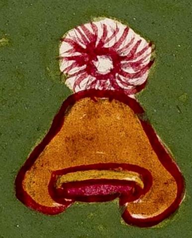
This compound glyph names the community of Pazolco (also spelled Pazulco), an estancia (subject community) of the larger town today called Yecapixtla (Morelos). It appears on the map of the Relación Geográfica de Acapistla dating from 1581. The glyph consists of a tepetl), hill or mountain, with a briar patch (pazolli) on its summit. This briar patch is shown as a thick circle with a large number of wavy, pointed prongs radiating out of it, all in red. The briar patch element is set in an uncolored circle on an otherwise green background. The hill has a thick red outline and is filled in with brown pigment. At its curled base are two bars, a yellow one with curved ends embracing a red one below it (reversing a more normal configuration; see below). The two bars are outlined in red, as well. The locative -co, in, at, is not represented visually. However, while the word tepetl is not part of the core of the place name, the hill undoubtedly serves as a semantic indicator of “place.” The town’s name, then, could be translated as “at/in the briar patch.”
Robert Haskett
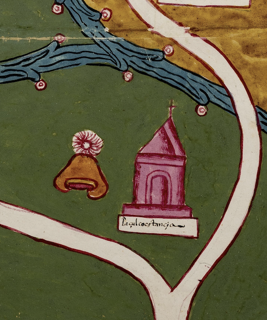
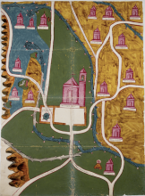
The Acapistla (sic) map is full of bold colors and thick outlines, most of which are red instead of the more usual black. The compound glyph appears to the left of a church, the latter of which has a gloss (see below) in a white rectangle at its base (see the historical contextualizing image). This church is outlined in red and is painted a lighter red or pink inside of this. Facing the reader in frontal view, it sits on a thick rectangular base. There is a large arched doorway above this. The roof consists of two pyramidal elements, the larger of which is surmounted by a cross. Both the compound glyph and church sit in a dark green field. The church is a semantic element for “inhabited place,” a convention found in other RG maps (such as the one for Cempohuallan; see other entries in this Visual Lexicon). On the present map, Pazolco is bounded by two curving white roads, outlined in red, and a blue, forked swirling waterway studded with nodes tipped with round, pink droplets (or precious gems). An area of brown territory is seen above this (see the historical contextualizing image). For more information about this RG see Mundy (1996); this author suggests (pg.149) that the hill part of the glyph indicates that Pazolco was an altepetl. However, its status as a relatively small community subordinate to Yecapixtla casts some doubt on whether Pazolco enjoyed this more elevated civic stature in the 1580s.
Robert Haskett
Paçulco estançia
Pazolco estancia
Robert Haskett
1581
Robert Haskett
briar patches, zarzales, enredos, hills, mountains, cerros, montañas, nombres de lugares
This important Indigenous community, part of the Cortés Marquesado del Valle jurisdiction, was glossed in various ways over time (Acapixtla, Acapiztla, Yecapiztlan, Yacapixtlan, Yacapichtlan, Ayacapitztlan, etc.). The modern spelling is Yecapixtla.

pazol(li), briar patch, https://nahuatl.wired-humanities.org/content/pazolli
tepe(tl), hill, mountain, https://nahuatl.wired-humanities.org/content/tepetl
-co (locative suffix), in or at, https://nahuatl.wired-humanities.org/content/co
En el zarzal
Robert Haskett
Relación de Acapistla – University of Texas Libraries Collections, 1580-11-15. https://collections.lib.utexas.edu/catalog/utblac:740d6d5b-280a-45f4-a3b...
Materials that are in the public domain (such as most of the maps in the PCL Map Collection) are not copyrighted, and no permission is needed to copy them. You may download them and use them as you wish. The image appears here courtesy of the University of Texas Libraries, The University of Texas at Austin. If you do publish anything from this database, please cite the Visual Lexicon of Aztec Hieroglyphs.


