Quiyotepec (CmpRG)
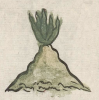
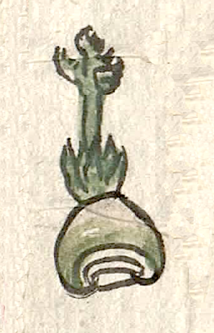
This compound glyph stands for Quiyotepec (also seen as Quiotepec, such as in the state of Oaxaca). Here it is the name of a landscape feature that appears on the 1580 Relación Geográfica de Cempoala (Cempohuallan, or Zempoala, Hidalgo, today). It consists of what looks like a green agave plant with a large stem with foliage or perhaps flowers on its top extending up from it. This is the quiyotl) element, a word meaning “stem, shoot, or sprout.” This plant is situated on top of a rounded tepetl) (hill, mountain) with three black-bordered lines at its base, the upper two curling in at each of their ends. These lines are not colored internally. The hill, painted green fading to tan at its summit, is smooth sided, making it a somewhat simplified version of a more typical, earlier-colonial glyph (see below). Aside from giving the place name its -tepe- element, the hill appears to serve as a semantic indicator for the otherwise non-visualized locative -c, “in, on, at, etc.”
Robert Haskett
The compound glyph appears near one edge of the map. It is situated not far from the glyph and gloss for the Zempoalan cabecera (head town) of Tlaquilpa. Quiyotepec is not associated closely with a church structure, however. Since on this map churches tend to be semantic indicators for inhabited communities, the likelihood is that Quiyotepec is a landscape feature rather than a town or hamlet. For more information about the map, see Biblioteca Digital Mexicana, A.C., http://bdmx.mx/documento/mapas-relaciones-geograficas-cempoala-epazoyuca... Mundy, Barbara E., “Mapping Babel: A Sixteenth-Century Indigenous Map from Mexico,” The Appendix, 1:4 (October 2013), and the same author’s book, The Mapping of New Spain: Indigenous Cartography and the Maps of the Relaciones Geográficas (Chicago and London: The University of Chicago Press, 1996).
Robert Haskett

quiotepec
Quiyotepec
Robert Haskett
1580
Robert Haskett
flora, plants, plantas, herbs, yerbas, sprouts, brotes, stem, tallos, shoots, retoños, hills, mountains, cerros, nombres de lugares
quiyo(tl), the stem, shoot, or sprout of an herb or vegetable, https://nahuatl.wired-humanities.org/content/quiyotl
Quiyotepec, a place name, https://nahuatl.wired-humanities.org/content/quiyotepec
tepe(tl), hill, mountain, https://nahuatl.wired-humanities.org/content/tepetl
-c (locative suffix), in, on, at
el cerro de las yerbas, el cerro de los retoños, etc.
Robert Haskett
Relación de Cempoala - University of Texas Libraries Collections. 1580-11-01. https://collections.lib.utexas.edu/catalog/utblac:f87917e2-e3c9-4eb2-a83...
Materials that are in the public domain (such as most of the maps in the PCL Map Collection) are not copyrighted, and no permission is needed to copy them. You may download them and use them as you wish. The image appears here courtesy of the University of Texas Libraries, The University of Texas at Austin. If you do publish anything from this database, please cite the Visual Lexicon of Aztec Hieroglyphs.