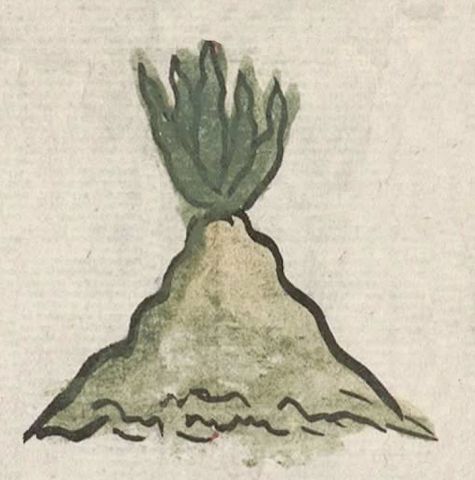
Metepec (CmpRG)
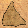
This compound glyph names the place known as Metepec. It appears on the map accompanying the 1580 Relación Geográfica de Cempoala (Hidalgo). The black-outlined glyph consists of a green and tan hill or mountain (tepetl) with a maguey plant (metl) sprouting from its summit. Everything is outlined in black. The naturalistic rendering of the tepetl, which rather than the standard Indigenous convention resembles a volcanic cone as far as its shape is concerned, is shaded in green fading to browns and tans, while the five-spiked maguey is shaded in dark green. The style of the image suggests a certain amount of Spanish influence in the work of the artist who painted it. The locative -c is not visualized specifically, but perhaps the landscape provides a semantic locative.
Robert Haskett
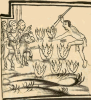
This compound glyph for Metepec appears on the center left of the map. It straddles a red boundary line, placing it within and sitting across two long, narrow rectangular areas also outlined in red. These boxes, found all over the map, are elements that Barbara E. Mundy believes are marking off divisions between territories that held Cempoala’s subject communities. Whether or not Metepec is a natural feature, a volcanic cone in the landscape, or also stands for the name of an inhabited place is not certain. According to Peter Gerhard, for instance, the Cempoala region is “a rolling, maguey-covered country of volcanic cones rising slightly above the plain…” (PG. 67). The convention on the map for depicting a community seems to be the placement of an Indigenous-style place glyph adjacent to a rendering of a Catholic church. The Spanish text of the Relación states that all of Cempoala's dependencies have churches. There is one nearby, but it sits outside the red boundary line on Metepec’s left, rather than inside the box there (see the historical contextualizing image). This suggests that the church may be related to one of the other places illustrated in a very large rectangular, red-line-bordered area that sits next to the much smaller area featuring the Metepec glyph. The Spanish text of the Relación is no help, since it does not seem to name a place or a natural feature called Metepec. For more information about this Relación, see Mundy, Barbara E., “Mapping Babel: A Sixteenth-Century Indigenous Map from Mexico,” The Appendix, 1:4 (October 2013), Mnndy (1996), particularly pg. 129 and her discussion of the function of the red lines seen on the map, and Ballesteros García (2005), 63. For information about the Cempoala region, see Gerhard, Historical Geography of New Spain (1972).
Robert Haskett

metepec
Metepec
Robert Haskett
1580
Robert Haskett
hills, mountains, cerros, montañas, magueyes, agaves, century plants, nombres de lugares
me(tl), maguey cactus, century plant, agave, https://nahuatl.wired-humanities.org/content/metl
tepe(tl), hill, mountain, precipice, https://nahuatl.wired-humanities.org/content/tepetl
El Cerro del Maguey
Stephanie Wood
Relación de Cempoala - University of Texas Libraries Collections. 1580-11-01. https://collections.lib.utexas.edu/catalog/utblac:f87917e2-e3c9-4eb2-a83...
Materials that are in the public domain (such as most of the maps in the PCL Map Collection) are not copyrighted, and no permission is needed to copy them. You may download them and use them as you wish. The image appears here courtesy of the University of Texas Libraries, The University of Texas at Austin. If you do publish anything from this database, please cite the Visual Lexicon of Aztec Hieroglyphs.