Tecocomolco (CmpRG)
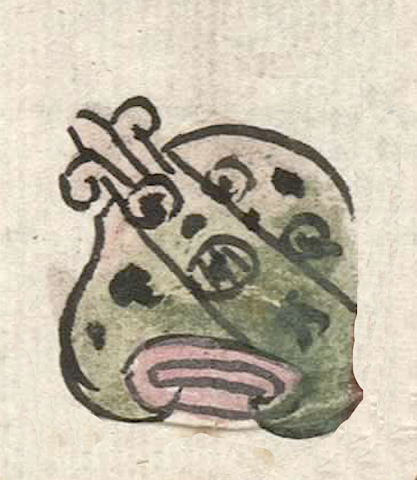
This is a compound glyph naming the community called Tecocomolco. It is featured in the 1580 Relación Geográfica de Cempoala (originally Cempohuallan, and now Zempoala, Hidalgo). It consists of a hill (tepetl) with a diagonal and elongated element meaning rock or stone (tetl) (an element found on other glyphs on the map) serving as a phonetic indicator for the Te- start to the place name. At first glance, the longer part, cocomol as it is written in the accompanying alphabetic gloss (see below) appears to be from the noun cocomolli, meaning “ravine.” However, because the glyph itself is covered with small black circles and dots, what may be indicated here is a reduplication of the noun comolli, “gully or depression.” With the locative ending -co, “in, at,” the name may mean “at the stony pot holes/gullies.” (The tepetl can serve as a silent locative.) In fact, a related word, cocomoltic does indeed mean “a place full of gullies.” The compound glyph is outlined in black, though part of that was lost on its right side when a red boundary line was painted over it. The hill, which serves as a semantic indicator for the locative, is tan near its peak, turning to green on its middle and lower slopes. The elongated stone element shares this coloring. Some of the circles on the hill are solid black dots (possibly indicating small or shallow caves; on this map, caves are indicated by larger solid black circles), others have small black dots inside them, and one of them in the middle of the glyph has three narrow black lines drawn over a small black dot. The base of the hill boasts the common element of three black-outlined bars, the top one curling around the others at its ends, filled with faded red pigment.
Robert Haskett
Typical of the Cempohuallan map, the compound glyph is paired with a drawing of a church as well as its alphabetic gloss (see the historical contextualizing image). These church structures usually act as semantic indicators of “an inhabited place,” which seems to be the case here, too. For more information about the RG map, see Biblioteca Digital Mexicana, A.C., http://bdmx.mx/documento/mapas-relaciones-geograficas-cempoala-epazoyuca... Mundy, Barbara E., “Mapping Babel: A Sixteenth-Century Indigenous Map from Mexico,” The Appendix, 1:4 (October 2013), Mundy (1996), and Ballesteros García (2005), particularly page 62 for a different analysis.
Robert Haskett
tecocomolco
Tecocomolco
Robert Haskett
1580
Robert Haskett
hills, cerros, stones, piedras, ravines, arroyos, gullies, depressions, barrancos, barrancas, nombres de lugares
te(tl), stone, rock, https://nahuatl.wired-humanities.org/content/tetl
comol(li), gully or depression, https://nahuatl.wired-humanities.org/content/comolli
cocomol(li), ravine, https://nahuatl.wired-humanities.org/content/cocomolli
cocomol(tic), a place full of gullies, https://nahuatl.wired-humanities.org/content/cocomoltic
tepe(tl), hill, mountain, https://nahuatl.wired-humanities.org/content/tepetl
-co, in, at, https://nahuatl.wired-humanities.org/content/co
Relación de Cempoala - University of Texas Libraries Collections. 1580-11-01. https://collections.lib.utexas.edu/catalog/utblac:f87917e2-e3c9-4eb2-a83...
Materials that are in the public domain (such as most of the maps in the PCL Map Collection) are not copyrighted, and no permission is needed to copy them. You may download them and use them as you wish. The image appears here courtesy of the University of Texas Libraries, The University of Texas at Austin. If you do publish anything from this database, please cite the Visual Lexicon of Aztec Hieroglyphs.