Tlalatlauhco (Mdz32r)
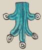
This compound glyph for the place name Tlalatlauhco features land parcels {tlalli) that open into a ravine (atlauhtli), from which water {atl) flows. The land parcels are purple in color and textured to point to agricultural activity on the land. The upper parcel is tipped up on an angle. The water flows toward the viewer's right. It has the typical black lines of current and white turbinate shells and white water droplets (which some see as symbolic for local jade stones, chalchihuitl) splashing off the top and at the end of the stream that drops down. The locative suffix (-co) is not shown visually, but perhaps the landscape provides a semantic locative.
Stephanie Wood
Stephanie Wood
tlalatlauco.puo
Tlalatlauhco, pueblo
Stephanie Wood
c. 1541, or by 1553 at the latest
Stephanie Wood
The land and the water are the two most prominent elements, but we could say that there are three elements, given the way the land parts, implying the ravine.
tierras, parcelas, agricultura, barrancos, agua, nombres de lugares

tlal(li), land, parcels, https://nahuatl.wired-humanities.org/content/tlalli
atlauh(tli), ravine, https://nahuatl.wired-humanities.org/content/atlauhtli
a(tl), water, https://nahuatl.wired-humanities.org/content/atl
-co (locative suffix, https://nahuatl.wired-humanities.org/content/co
Codex Mendoza, folio 32 recto, https://digital.bodleian.ox.ac.uk/objects/2fea788e-2aa2-4f08-b6d9-648c00..., image 74 of 188.
The Bodleian Libraries, University of Oxford, hold the original manuscript, the MS. Arch. Selden. A. 1. This image is published here under the UK Creative Commons, “Attribution-NonCommercial-ShareAlike 3.0 License” (CC-BY-NC-SA 3.0).