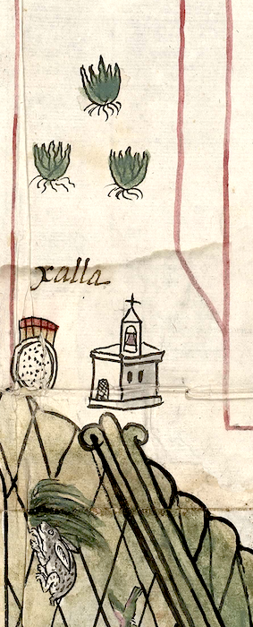
Xallan (CmpRG)
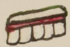
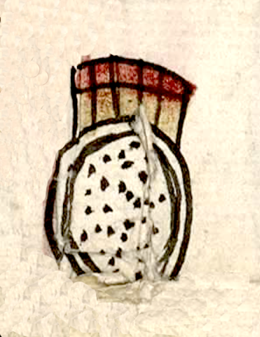
This is a complex glyph naming the town called Xallan (perhaps "Near the Sand"). It is featured in the 1580 Relación Geográfica de Cempoala (originally Cempohuallan, and now Zempoala, Hidalgo). The glyph consists of a double circle outlined in black and filled with black dots, standing for sand (xalli) and a second part on its top rim made up of a row of black-outlined rectangles filled with tan pigment and with red-filled squares above them. At first glance, this makes the glyph look like a shield with the ends of arrows sticking up from behind the shield (as seen in the glyph for Chimalpopoca, below). However, it would make more sense of this second element represents a set of teeth (tlantli), with the “t” disappearing when it is combined with the final “l” of the root word. If so, this element would thus be a phonetic indicator for the locative -tlan, which means “near, by, among,” and the like. Alternately, the teeth could stand phonetically for a similar locative, -tla, indicating “an abundance of something,” in this case sand. Of course, the multiple dots within in the double circle could be semantic indicators of abundance, too. The alphabetic gloss (see below) does not have a final “-n” written on it, although these are often left off, making a definitive conclusion difficult. Either way, the place name would end up referring to a sandy place adjacent to where the town was established.
Robert Haskett
There is a three-quarters view of a church sitting to the right of the compound glyph. On the map, this figure usually serves as a semantic indicator for an inhabited place. The glyph and church, along with a trio of maguey plants showing their roots, are placed within an area marked off by red border lines, which art historian Barbara Mundy suggests indicate the territories of Cempohuallan’s subject communities. According to this same author, one of the subject towns of the cabecera (head town) of Epazoyuca was Xala (sic). The Cempohuallan map does illustrate some of the communities of this other town, yet this Xalla/Xallan abuts the lower edge of Cempohuallan’s main compound place glyph (see the historical contextualizing image). This suggests a very close relationship between Xalla/Xallan and Cempohualla, hinting that this is not the Epazoyuca dependency. Unfortunately, we may never know for certain. At any rate, the positioning of the present compound glyph and a seam between two sheets of paper mean that some of the lower outlines of the double circle are lost. For more information about the RG map, see Biblioteca Digital Mexicana, A.C., http://bdmx.mx/documento/mapas-relaciones-geograficas-cempoala-epazoyuca... Mundy, Barbara E., “Mapping Babel: A Sixteenth-Century Indigenous Map from Mexico,” The Appendix, 1:4 (October 2013), Mundy (1996), 129, and Ballesteros García (2005), 52.
Robert Haskett
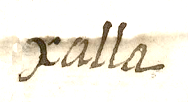
xalla
Xallan/Xalla
Robert Haskett
1580
Robert Haskett
sands, las arenas, sandy, arenoso, rodelas, escudos, nombres de lugares
xal(la), sandy place, https://nahuatl.wired-humanities.org/content/xalla
xal(li), sand, https://nahuatl.wired-humanities.org/content/xalli
-tla, place with an abundance of something, https://nahuatl.wired-humanities.org/content/tla-1
-tlan, near, by, in, among, https://nahuatl.wired-humanities.org/content/tlan
Arenal, o Lugar Arenoso
Robert Haskett and Stephanie Wood
Relación de Cempoala - University of Texas Libraries Collections. 1580-11-01. https://collections.lib.utexas.edu/catalog/utblac:f87917e2-e3c9-4eb2-a83...
Materials that are in the public domain (such as most of the maps in the PCL Map Collection) are not copyrighted, and no permission is needed to copy them. You may download them and use them as you wish. The image appears here courtesy of the University of Texas Libraries, The University of Texas at Austin. If you do publish anything from this database, please cite the Visual Lexicon of Aztec Hieroglyphs.