Atl Amaxac (CmpRG)
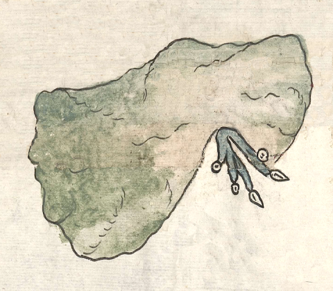
This is a compound glyph naming the town called Atl Amaxac. It is featured in the 1580 Relación Geográfica de Cempoala (originally Cempohuallan, and now Zempoala, Hidalgo). It consists of the term for water (atl) and a second word meaning “where the water divides” (amaxac), the final -c acting as a locative indicating the place where something happens. The large bifurcated hill (tepetl) is a semantic indicator for the “division” of the waters seen issuing out of it, as well as for the locative. There is a possible alternative reading, however. Maxactli can mean “crotch,” among other things, and the configuration of the hill could be interpreted as showing a crotch-like feature. If this is so, then the “a-“ of amaxac would be a second statement of atl, combining with the initial term to emphasize the watery nature of the place and name. Whatever the case, the naturalistic hill has an uneven black outline as well as wavy black lines in its interior, all of this depicting contours (three-dimensionality). The hill is colored tan and brown in its central part, with greens on its upper part and sides. The water symbol points down, coming down and out from the “crotch” or division of the hill. It has four or perhaps five “streams,” three of them tipped with round droplets (or precious gems) and the two with turbinate shells, all of them uncolored. The water itself is painted blue.
Robert Haskett
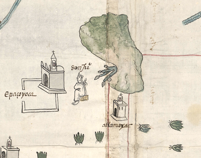
On the map, Atl Amaxac is sited near the church and atrium of the cabecera (head town) of Epazoyuca, as well as the seated figure of an elite-class male glossed as “don Juan” (see the historical contextualizing image). The Atl Amaxac glyph itself is associated with another, smaller church in three-quarter view, under which the alphabetic gloss of this place appears (see below). As is common elsewhere on the map, the church serves as a semantic indicator for “inhabited place.” Whether or not Atl Amaxac is a subject community of Epazoyuca or Cempohuallan is not clear. For more information about the RG map, see Biblioteca Digital Mexicana, A.C., http://bdmx.mx/documento/mapas-relaciones-geograficas-cempoala-epazoyuca... Mundy, Barbara E., “Mapping Babel: A Sixteenth-Century Indigenous Map from Mexico,” The Appendix, 1:4 (October 2013), Mundy (1996), and Ballesteros García (2005), 64.
Robert Haskett
atlamaxac
Atlamaxac/Atl Amaxac
Robert Haskett
1580
Robert Haskett
water, agua, hills, mountains, cerros, nombres de lugares

a(tl), water, https://nahuatl.wired-humanities.org/content/atl
amaxac, place where a river breaks into many streams, https://nahuatl.wired-humanities.org/content/amaxac
amaxac(tli), place where the river divides, https://nahuatl.wired-humanities.org/content/amaxactli
maxac(tli), crotch, fork, https://nahuatl.wired-humanities.org/content/maxactli
-c, tells where, a locative, https://nahuatl.wired-humanities.org/content/c
Relación de Cempoala - University of Texas Libraries Collections. 1580-11-01. https://collections.lib.utexas.edu/catalog/utblac:f87917e2-e3c9-4eb2-a83...
Materials that are in the public domain (such as most of the maps in the PCL Map Collection) are not copyrighted, and no permission is needed to copy them. You may download them and use them as you wish. The image appears here courtesy of the University of Texas Libraries, The University of Texas at Austin. If you do publish anything from this database, please cite the Visual Lexicon of Aztec Hieroglyphs.


