Tlecaxapan (CmpRG)
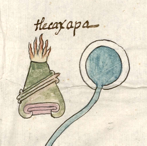
This compound glyph stands for a natural landscape feature called Tlecaxapan. It is found on the map of the 1580 Relación Geográfica de Cempoala (originally Cempohuallan, or today, Zempoala, Hidalgo). The compound consists of several component parts that appear in two separate elements. One of them is a tepetl) spouting fire (tletl) from its summit in the manner of a volcano. This hill/mountain serves two roles: it is a semantic indicator for place, but more centrally it symbolizes the word tlecaxitl), an incense burner or brazier (in other words, a container of fire). The hill also has a band running diagonally across it, which is an elongated element meaning rock or stone (tetl) outlined in black with a tan-colored interior. It may serve as a semantic indicator showing that the hill is rocky (and tepetl begins with te-). The second, separate element to the right of the hill is a black-bordered circle with a sky-blue center. This represents the locative -apan, “on or at the water,” and in this way is also a semantic indicator that there is a water feature nearby. Together, the two words combine as “brazier (fire container) by the water.”
Robert Haskett
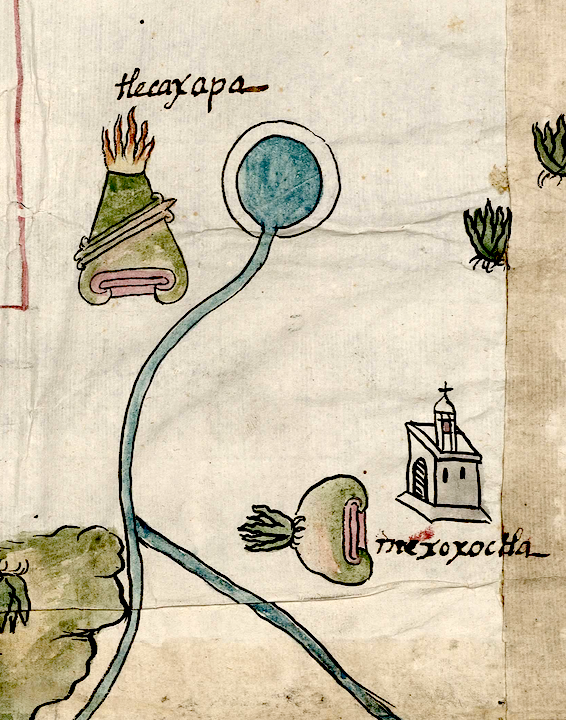
This hill or mountain may be the same one mentioned in the Relación’s Spanish language text as Tlecaxtitlan, one of the most important cerros in the area located near a water source or water feature. According to the alphabetic text, the name means “cerro echo a manera de brazero” (“a hill formed in a way [that looks] like a brazier;” folio 1 recto). The ending of the word written in the Spanish text, -titlan, is another way of saying “next to, with,” etc. Absent a second, similar feature painted on the map, it seems likely that this is the same hill or mountain that may have been known by more than one name, not an unprecedented occurrence (Stephanie Wood, personal communication, April 30, 2023). Since it is not associated closely with an image of a church (see the historical contextualizing image), and given the conventions of this placement on the map, the name is not that of an inhabited community. Diagonal “rocky” bands on the tepetl elements are found elsewhere on the map, such as on the compound glyph for Cempohuallan itself, and in the glyph for Xochitepec (see below). For more information about the map, see Biblioteca Digital Mexicana, A.C., http://bdmx.mx/documento/mapas-relaciones-geograficas-cempoala-epazoyuca... Mundy, Barbara E., “Mapping Babel: A Sixteenth-Century Indigenous Map from Mexico,” The Appendix, 1:4 (October 2013), Mundy (1996), and Ballesteros García (2005), 63-64.
Robert Haskett
tlecaxapa
Tlecaxapan
Robert Haskett
1580
Robert Haskett
There are two main elements, the fire-topped hill and the water feature, with one or two other semantic indicators associated with the hill.
fire, fuego, braziers, braseros, waters, aguas, stones, rocks, piedras, hills, mountains, cerros, nombres de lugares

tlecaxi(tl)i, a ceramic incense burner, a brazier, https://nahuatl.wired-humanities.org/content/tlecaxitl
-apan, on or at the waters of, https://nahuatl.wired-humanities.org/content/apan-0
tle(tl), fire, https://nahuatl.wired-humanities.org/content/tletl
tepe(tl), hill, mountain, https://nahuatl.wired-humanities.org/content/tepetl
te(tl), stone, rock, https://nahuatl.wired-humanities.org/content/tetl
el brasero donde esta el agua
Robert Haskett
Relación de Cempoala - University of Texas Libraries Collections. 1580-11-01. https://collections.lib.utexas.edu/catalog/utblac:f87917e2-e3c9-4eb2-a83...
Materials that are in the public domain (such as most of the maps in the PCL Map Collection) are not copyrighted, and no permission is needed to copy them. You may download them and use them as you wish. The image appears here courtesy of the University of Texas Libraries, The University of Texas at Austin. If you do publish anything from this database, please cite the Visual Lexicon of Aztec Hieroglyphs.


