Nopalapan (CmpRG)
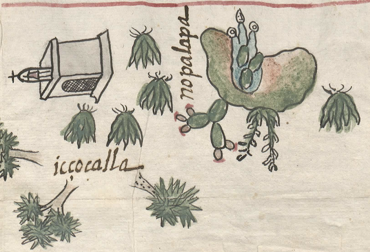
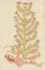
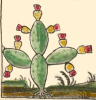
This is a compound glyph for the toponym Nopalapan ("On the Nopal Waters"). It appears on the map included with the 1580 Relación Geográfica de Cempoala (originally, Cempohuallan) of the contemporary state of Hidalgo. It features a somewhat stylized depiction of a hill or mountain (tepetl with a downward flowing body of water--most likely an apantli--and three superimposed images of nopal cactus pads (pencas, in Spanish). In combination, this gives nopalapan, including the locative -apan (“on or at the waters”). The prickly pear cactus sprouting from the right top of the hill is a semantic complement for the nopal part of the place name, while the function of the other plant element to its left (which looks something like a blooming century plant) is not obvious; it may be a semantic indicator flagging the kind of flora commonly found in the area. The tepetl element does not contribute directly to the composition of the name represented by the glyph. It appears to be another semantic indicator underlining that this is a named feature in the area as well--as the source of the water bearing its name. All of the elements of the glyph are outlined in black. The hill is shaded with green fading to browns. The water element is blue and the three superimposed nopal pads are green. The water has three prongs hanging down, two of them tipped with droplets (or precious gems) and the one in the middle with a turbinate shell, all of them uncolored. The nopal and the plant next to it are shaded in green. The nopal fruit is pink topped with what appear to be red flowers, while some of what may be blossoms on the other plant are left uncolored.
Robert Haskett
This compound glyph may stand for the settlement of Nopalapan, one of three dependencies (sujetos) of the cabecera of Tlaquilpa that are listed in the Relación’s Spanish text. The norm on the map is for inhabited places to be associated with the drawing of a church. There is such a structure nearby, separated from the compound glyph by some maguey plants, but this church is just as close to another glossed place called icçocalla (Iczocallan). This latter place does not have an obvious glyphic representation, but it is among some tree-like elements that could represent yucca plants (iczotl) (see the historical contextualizing image). Given that Nopalapan was a significant inhabited place at the time the map was likely to have been created, however, its compound glyph most likely refers to both a landscape feature and the sujeto of that name (for a similar case, see the MC RG entry for Huitznahuac). As to the presence of cacti and maguey plants near the hill that serves as the base for the compound glyph, they may well be semantic indicators for the flora growing in what Peter Gerhard describes as a region of “a rolling, maguey-covered country of volcanic cones rising slightly above the plain,” which, by the later sixteenth century, was becoming a center for the commercial production of pulque. See his Historical Geography of New Spain (1972), 67-68. For more information about the Relación, see Mundy, Barbara E., “Mapping Babel: A Sixteenth-Century Indigenous Map from Mexico,” The Appendix, 1:4 (October 2013), Mundy (1996), 132, and Ballesteros García (2005), 68, figure 40, who, however, does not account for all of the elements in the glyph.
Robert Haskett
nopalapa
Nopalapan
Robert Haskett
1580
Robert Haskett
place name, canal, nopal cactus, nopalli, nochtli, prickly pear cactus, landscape feature

nopal(li), nopal cactus, nopal, prickly pear cactus, https://nahuatl.wired-humanities.org/content/nopalli
apan(tli), canal, water ditch, https://nahuatl.wired-humanities.org/content/apantli
-apan, on or at the waters of, a locative suffix found on place names where there is a canal or river, https://nahuatl.wired-humanities.org/content/apan-0
Relación de Cempoala - University of Texas Libraries Collections. 1580-11-01. https://collections.lib.utexas.edu/catalog/utblac:f87917e2-e3c9-4eb2-a83...
Materials that are in the public domain (such as most of the maps in the PCL Map Collection) are not copyrighted, and no permission is needed to copy them. You may download them and use them as you wish. The image appears here courtesy of the University of Texas Libraries, The University of Texas at Austin. If you do publish anything from this database, please cite the Visual Lexicon of Aztec Hieroglyphs.